Modern sea-level rise breaks 4,000-year stability in southeastern China
Summary
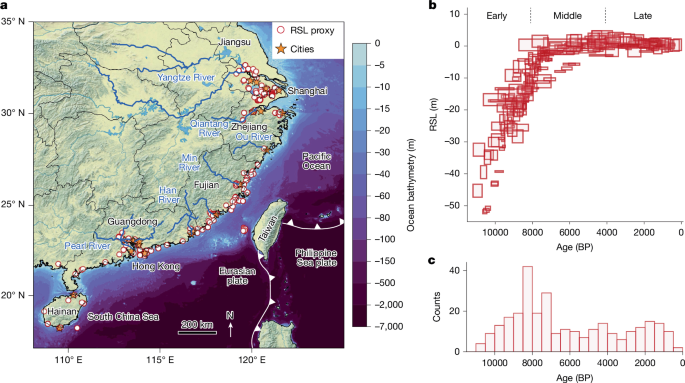
This Nature paper presents a process-based reconstruction of relative sea level (RSL) for southeastern China through the Holocene and compares that geological baseline with modern instrumental records. Using a spatiotemporal hierarchical model that combines a glacial isostatic adjustment (GIA) ensemble and Gaussian-process priors, the authors decompose Chinese RSL change into GMSL (global mean sea level), GRD (gravitational, rotational and deformational) effects, a spatially varying linear term (tectonics and long-term sediment processes), regional nonlinear terms (ocean/atmosphere dynamics) and local nonlinear terms (site-scale processes). The reconstruction uses nearly 300 palaeo sea-level proxies, tide gauges and modern VLM (vertical land motion) data.
Article Date: 15 October 2025
Article URL: https://www.nature.com/articles/s41586-025-09600-z
Article Image: https://media.springernature.com/lw685/springer-static/image/art%3A10.1038%2Fs41586-025-09600-z/MediaObjects/41586_2025_9600_Fig1_HTML.png
Key Points
- Modern global mean sea level (GMSL) rise has accelerated to 1.51 ± 0.16 mm yr−1 (1900–2020), a rate that is extremely likely to exceed any century in the past 4,000 years for southeastern China.
- The GMSL signal now dominates the regional sea-level budget: its contribution rose from ~19.6% in the pre-industrial late Holocene to ~79% post-1900 across 20 major coastal cities.
- Regional nonlinear variability (centennial to multicentennial), linked to internal climate variability such as ENSO and the PDO, produced a persistent dipole pattern between eastern (Yangtze delta area) and southern (Fujian–Guangdong) China during the Holocene and in the twentieth century.
- Long-term geological VLM (uplift/subsidence) varies strongly by physiography: tectonically active Fujian shows uplift; major deltas (Yangtze, Pearl) show sustained natural subsidence due to sediment compaction and isostatic adjustment.
- Modern urban subsidence is overwhelmingly anthropogenic. InSAR data (2015–2022) show citywide median subsidence up to ~5.6 mm yr−1 (Chaozhou), with anthropogenic processes accounting for >94% of observed subsidence in most cities.
- The nineteenth century marks the emergence of modern sea-level rise: probabilities for persistent decadal GMSL rise surged in the mid-1800s and became virtually certain by 1880.
- Methodologically, the study integrates a GIA model ensemble (360 ice–Earth combinations) with Gaussian processes and validates results against non-China proxy records and modern GNSS/InSAR VLM products.
Content summary
The paper compiles a comprehensive southeastern China RSL database (≈292 SLIPs) and applies PaleoSTeHM, a spatiotemporal hierarchical modelling framework. The authors separate the signal into nine components (fast/slow global terms, GIA barystatic and GRD parts, a spatial linear term, regional nonlinear and local nonlinear terms). Key Holocene findings: rapid early Holocene GMSL rise (≈10.7 mm yr−1), slowdown by 6000 BP and near-stability from ~4200 BP to the mid-1800s. Regionally, GRD effects and sedimentary/tectonic processes produced strong spatial contrasts — e.g. higher GRD uplift on the broad continental shelf of Jiangsu/Zhejiang than near Sanya.
Comparing this geological baseline with modern instrumental reconstructions shows a systematic shift: 20th–21st-century acceleration in GMSL has overwhelmed regional processes that previously controlled local RSL variability. At the same time, urbanisation-driven subsidence (measured by InSAR and GNSS) sharply amplifies local RSL and flood exposure, especially over thick, unconsolidated Holocene deposits in megadeltas.
Context and relevance
Southeastern China hosts 100+ million people and critical economic infrastructure. Placing modern sea-level rise into a 11,700-year Holocene context reveals that the current, anthropogenically driven GMSL acceleration is unprecedented in four millennia for this region. That conclusion matters because it reframes risk: city-level flood exposure now combines global warming-driven GMSL, chaotic internal climate variability and local human-driven subsidence — all of which require different planning responses.
Author style
Punchy: the paper is a clear flag-waving result — modern warming has pushed GMSL into rates not seen for ~4,000 years in one of the world’s most densely populated coasts. If you work on coastal risk, adaptation or climate attribution, the regional decomposition and city-level VLM comparisons are especially worth digging into.
Why should I read this?
Short answer: because it shows southeast China is living with a new normal. The study saves you the slog of parsing dozens of proxy and GNSS/InSAR papers by bringing them together and showing how global sea-level change, natural geological motions and human subsidence combine to set modern flood risk. If your work touches coastal planning, infrastructure, or climate adaptation — read the methods and city budgets; they tell you where the real vulnerability is.